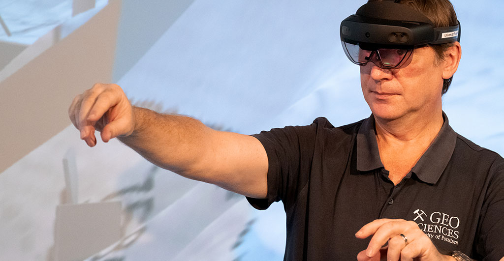
“Many people cannot imagine complex objects in space when they see them on a flat plan or map. If, for example, a wind turbine is to be erected or a dike built, the easiest way to convey the effects is in the real landscape itself,” says Gerold Zeilinger. This is made possible with augmented reality technology, which Zeilinger, a geologist, is adapting for landscape planning. “We don’t take a digital image of nature and show it in a visualisation in a room or in a lab; we go to the place where it happens, outside. That’s the innovation,” Zeilinger emphasizes. Municipalities, environmental agencies, landscape design firms, architectural firms, and even the construction industry can work with it to better discuss planned changes and make decisions, Zeilinger says.
His project, “Visualizing Landscape Changes Using AR in Real Environments,” received a FöWiTec award in 2021, with which the University of Potsdam financially supports knowledge and technology transfer. The idea for the project grew out of the 3D laboratory that Zeilinger has headed at the Institute of Geosciences since 2011. In this lab, multidimensional data sets are projected spatially to visually analyze data structures as well as their internal relationships. Unlike with virtual reality (VR) headsets, in the 3D lab you aren’t looking at a pure computer image; you’re working together immersively on the object. This means that a 3D headset enables you to see digital objects floating in space. “This is a great advantage in terms of communication, as the participants in a group can see each other,” says Zeilinger. “This experience from the 3D lab – that the discussion track simply has to be open and you can capture the facial expressions and gestures of the others – is something we also want to implement with AR glasses.”
Furthermore, it’s possible to manipulate the virtual objects in their position directly on site, to calculate their effects on the server side, and then to visualize them again “just in time” on site. You can use gestures, for example, to grab a wind turbine and move it to another location, or to create a ditch or a dam. The spatial displacement of objects is possible with meter precision. The new position is sent to a geoinformation (GIS) server, which performs modified analyses or calculations, for example of the shadow that the object casts, and returns the result.
“As far as the technical requirements are concerned, we need 5G for our project – locally via a wireless network with a hub – as well as fast modeling,” explains Zeilinger. Fast here means with a precision that is sufficient to the project, yet still within an acceptable time so that the models can actually help make decisions. With future 5G coverage, Zeilinger expects the combination of on-site AR glasses and near-real-time modeling to become increasingly accurate.
Zeilinger was able to win over the company LandPlan OS GmbH, which is active in landscape planning, as a partner for his project. “They use tablets on which they can move the wind turbines. That part has already been implemented,” he says. “Currently, we are working together on triggering the analysis to the servers and feeding back the results.” He is supported at the University of Potsdam by project coordinator Leila Rezaei, geoinformatician Martin Schüttig, and an intern from the master’s program in “Remote Sensing, geoInformation and Visualization.” Simple analysis on the GIS server is already implemented; the interactions in the AR glasses and the geolocation of the glasses in the terrain are to follow. The goal is to have a good demonstration by mid-2023. “This prototype should work with four to five synchronized glasses,” Zeilinger says. His team has to ensure that the glasses display the objects in the correct position.
AR glasses change the perception of reality. The view in real time can be enriched by virtual elements such as texts, images, videos, or three-dimensional animations. Since everyone is not already familiar with AR glasses and there are sometimes anxieties about the technology, potential users will be able to put on AR glasses for a test in order to play through the whole thing in practical demonstrations, Zeilinger says. He is confident that the transfer idea he has developed will be able to support decisions on landscape-altering measures and also increasingly involve the population.
.
FöWiTec Prize for the Promotion of Knowledge and Technology Transfer
Potsdam Transfer – the central institution for innovation, start-ups, knowledge and technology transfer at the University of Potsdam – supports up to five application-oriented R & D projects each year with a total of 50,000 euros. Potsdam Transfer supports the development of the idea and, together with UP Transfer GmbH, ensures that the projects can be successfully implemented.
.
This text appeared in the University Magazine Portal Transfer – 2022/2023 (PDF).
.
Photo: Geoscientist Dr. Gerold Zeilinger wearing AR glasses. Photo: University of Potsdam/Sandra Scholz

